My View - Crummock Water
- Tony Allaker

- Feb 3, 2021
- 3 min read
Suggested photo locations around Crummock Water

Mellbreak fell from the east shore
This is the second of a series of blogs of my favourite photo locations, which will hopefully be helpful to some people less familiar with the area in question, and maybe inspire an idea or two for a day out. This post focuses on Crummock Water, which is in the north-west area of the Lake District. The map below (a screen shot from my Viewranger app, which is a fantastic app to support walking anywhere in the UK) shows seven areas I would recommend you to visit.

1 - North shore and Lanthwaite Wood
There is a National Trust car park conveniently situated a Lanthwite Wood. There are several walking trails through the wood, including up to Scale Hill which offers nice views and photo opportunities. The main route through the wood leads to Crummock Water north shore, where a classic lakeland view unfolds of Crummock Water and the surrounding fells. There are also focal points for photography such as the weir over which water rushes into the River Cocker, and the boathouse on the north-east shore. Lots of potential for great photos, especially at sunrise and sunset.

Grasmoor and boathouse reflections in late autumn

Winter sunrise by the weir

Mellbreak and weir reflections

The boathouse and Mellbreak fell
2 - Rannerdale Knotts bluebells
Each year in May the fells behind Rannerdale Knotts are covered in bluebells. Normally woodland plants, they are shaded from the summer sun by a covering of bracken. It is a very popular tourist spot and unfortunately there is often damage caused by tourists trampling some of the bluebells. The National Trust have roped off several areas to protect the plants. However, there are still many photo opportunities if you are careful and respect the guidelines. The best time to visit is early morning and late evening when it is quiet and the light is best for photography.

Bluebells and Rannerdale Knotts fell

Sunstar and Whiteless Pike fell

Footpath to Crummock Water

Bluebells galore!
3 - Rannerdale Knotts
Rannerdale Knotts is one of the more accessible Wainwright fells in terms of location and relatively low height. There are several parking areas at the base of the fell, and the views from the top are very rewarding.

View to Buttermere

The bluebells from the fell summit

View of Crummock Water and Mellbreak fell
4 - South shore
There is a particular location on the south shore, which isn't part of the circular walk around Crummock Water, where there is a rocky outcrop. On a calm day there are lovely views down the length of the lake with a chance of some nice reflections.

View from the south shore
5 - Scale Force
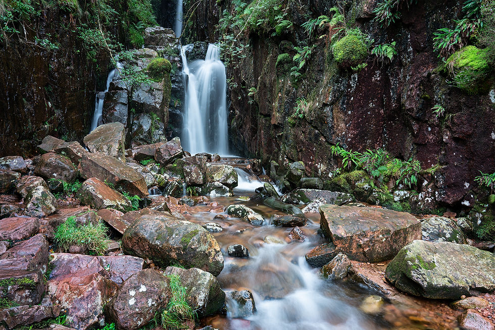
Tucked away in the south-western area of Crummock Water is the impressive Scale Force. It is considered to be the tallest waterfall in the Lake District and it is possible to get close up the base of the falls via a clear path. A good place for slow shutter speeds, polarising filters and tripods!

Scale Force
6 - Mellbreak fell
Mellbreak fell dominates the skyline on the western shore of Crummock Water, and features in several of the photos in this blog. It is a Wainwright and a great fell to hike, as once up there is a long relatively level ridge with brilliant views. There are two competing summits, one at the centre and one at the north end of the ridge.

A Herdwick sheep and views to Buttermere from Mellbreak fell southern slopes
7 - Shoreline circular walk
There is a circular walk around Crummock Water including a few opportunities for detours, e.g. to Scale Force. There are impressive views and photo opportunities to be add throughout. Here are some examples of what you can photograph:

Crummock Water south shore and the slopes of Red Pike fell

Robinson and Fleetwith Pike fells viewed from Crummock Water south-western shore

Grasmoor, Whiteless Pike and Rannerdale Knotts fells viewed from the north-western shore
So I hope you have found this blog useful/helpful if you plan to visit Crummock Water. Any feedback would be much appreciated.


Comments